Randonnée A pied Bayerisch Eisenstein - 8 Bayerisch Eisenstein - Großer Arbersee - Photo

8 Bayerisch Eisenstein - Großer Arbersee

Tous les sentiers balisés d’Europe PRO

© OpenStreetMap contributors
Longueur
Longueur
5,1 km
Altitude max
Altitude max
946 m
Dénivelé positif
Dénivelé positif
263 m
Km-Effort
Km-Effort  
7,8 km
Altitude min
Altitude min
681 m
Dénivelé négatif
Dénivelé négatif
14 m
Boucle
Boucle
Non
Balise
Balise
Date de création :
2022-02-11 13:17:00.778
Dernière modification :
2022-02-11 13:17:00.778

(0 Avis)

A pied
A pied
1h46
Difficulté : Facile

Scannez ce code QR pour ouvrir la randonnée dans l'application SityTrail

Application GPS de randonnée GRATUITE

Logo SityTrail SityTrail

IGN / Instituts géographiques

Télécharger SityTrail sur l'App Store Télécharger SityTrail sur Google Play

Logo SityTrail SityTrail World

Le monde est à vous

Télécharger SityTrail sur l'App Store Télécharger SityTrail sur Google Play Télécharger SityTrail sur Huawei AppGallery

À propos

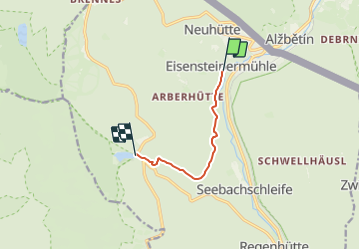
Randonnée A pied de 5,1 km à découvrir à Bavière, Landkreis Regen, Bayerisch Eisenstein. Cette randonnée est proposée par SityTrail - itinéraires balisés pédestres.

Description

Zwei Varianten des Symbols exisiteren: rechteckig und rund

Symbole: Weiße 8 auf rotem Grund

Photos

Localisation

Pays :
Allemagne
Région :
Bavière
Département/Province :
Landkreis Regen
Commune :
Bayerisch Eisenstein
Localité :
Unknown
Départ:(UTM)
367832 ; 5442142 (33U) N.

Randonnées à proximité

Randonnée A pied Bayerisch Eisenstein - 9 Bodenmais - Arbersee - Photo
A pied
PRO

A pied

Facile
Bayerisch Eisenstein, Bavière, Landkreis Regen, Allemagne
6,5 km | 10 km-effort
2h 16min
Non
Randonnée A pied Bayerisch Eisenstein - Waldmaus - Photo
A pied
PRO

A pied

Facile
Bayerisch Eisenstein, Bavière, Landkreis Regen, Allemagne
3,4 km | 5,7 km-effort
1h 17min
Oui
Randonnée A pied Bayerisch Eisenstein - Linde - Photo
A pied
PRO

A pied

Facile
Bayerisch Eisenstein, Bavière, Landkreis Regen, Allemagne
8,8 km | 11,1 km-effort
2h 31min
Non
Randonnée A pied Bayerisch Eisenstein - Bussard - Photo
A pied
PRO

A pied

Facile
Bayerisch Eisenstein, Bavière, Landkreis Regen, Allemagne
7,9 km | 11,9 km-effort
2h 42min
Oui
Randonnée A pied Lindberg - Ameise - Photo
A pied
PRO

A pied

Facile
Lindberg, Bavière, Landkreis Regen, Allemagne
3,1 km | 3,9 km-effort
53min
Oui
Randonnée A pied Lindberg - Siebenschläfer - Photo
A pied
PRO

A pied

Facile
Lindberg, Bavière, Landkreis Regen, Allemagne
7,3 km | 9,9 km-effort
2h 14min
Oui
Randonnée A pied Lindberg - Heidelbeere - Photo
A pied
PRO

A pied

Facile
Lindberg, Bavière, Landkreis Regen, Allemagne
8,2 km | 15,5 km-effort
3h 31min
Non
Randonnée A pied Lindberg - Eibe - Photo
A pied
PRO

A pied

Facile
Lindberg, Bavière, Landkreis Regen, Allemagne
4,2 km | 10,1 km-effort
2h 17min
Non
Randonnée A pied Bodenmais - Wanderweg 11 - Photo
A pied
PRO

A pied

Facile
Bodenmais, Bavière, Landkreis Regen, Allemagne
5,8 km | 7,3 km-effort
1h 39min
Non


Fermer
Mes abonnements